UP TO THE MINUTE
Nearmap Releases Panorama and Oblique Aerial Imagery Inside New MapBrowser Interface
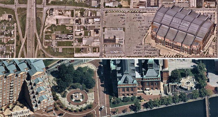
Vertical aerial imagery maps extended to include uninterrupted panorama imagery and measurable oblique images.
South Jordan, Utah—Nearmap, a location content provider specializing in high-resolution aerial maps, announces the release of new forms of location content — Nearmap Panorama and Nearmap Oblique — available through a new MapBrowser™ interface. Nearmap has long provided vertical imagery (also known as orthorectified imagery) covering about 70 percent of the U.S. population. Today, it extends its location content to include new aerial geospatial data services – Nearmap Panorama and Nearmap Oblique imagery.
Nearmap Panorama is unique since it enables users to view perspective maps in all cardinal directions for small or large areas in uninterrupted fashion. Users do not need to jump from one image to another and, in the process, lose context. They can easily navigate, pan and zoom across any size geography, quickly analyze perspective maps and make faster decisions that impact government and commercial operations – all within an instantly accessible 100 percent cloud-based environment.
“Nearmap Panorama is delivered via our new, highly intuitive MapBrowser interface, enabling users to effortlessly visualize and navigate across regions or local areas in an uninterrupted way,” said Patrick Quigley, SVP and GM for Nearmap North America. “Our users can inspect aerial location content faster than ever before using Nearmap Panorama. Consistent with past location content, Nearmap Panorama is delivered in high-resolution, 3-inch GSD.”
Nearmap Obliques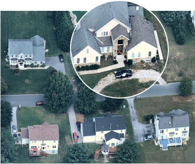 enable users to interactively inspect and measure the height of features, such as buildings and terrain, from all cardinal directions. Nearmap Oblique images are also accessed through the new MapBrowser.
“Our customers need location content aligned with their requirements,” said Natasha Ridley, product manager for MapBrowser. For example, with Nearmap Oblique images, government organizations conducting property appraisal can accurately value property using measurement and detailed, tilt-angled perspectives. At the same time, commercial organizations interested in engineering and construction can quickly select a north, south, east or west orientation, measure heights of buildings and better plan changes.”
Users working within MapBrowser can switch from Nearmap Vertical to Nearmap Panorama or Nearmap Oblique location content. “We’ve added new features that our customers are going to be very excited about,” said Ridley. “For example, now users can export our imagery with measurements added. The saved image provides the whole picture, which is very useful in proposal development and communicating specific aspects of the aerial maps essential in planning and operations.”
“These enhancements represent a major step forward in both our location content and delivery capabilities. There’s also more on the way,” said Robert Carroll, VP of 3-D commercial and government for Nearmap. “This imagery is produced by our patented HyperCamera2 technology, enabling us to continue to proactively survey the U.S. urban areas including 50 percent of the population with obliques while also producing high-resolution 3-D content. Our plan is to extend our leadership position by introducing Nearmap 3-D combining ‘off-the-shelf’ digital surface models (DSM), textured 3-D mesh and 3-D point clouds in the near future.”
Nearmap will be exhibiting at Autodesk University 2017 in Las Vegas from Nov. 14-16 at booth A503 in the Sands Expo/Venetian Hotel. There’s also a breakout session by Nearmap (“Aerial Imagery Transforming AEC”) on Nov. 15 at 9:15 a.m. You can learn more and set a meeting to see one of your projects in Nearmap.
Nearmap is also exhibiting at the International Association of Emergency Managers (IAEM) at the Long Beach Convention & Entertainment Centerin California from Nov. 13-15. Interested parties can visit Nearmap at booth 441, exhibit hall A.
About Nearmap Nearmap brings the real world to you. We capture, manage and deliver the most current location content in the world, allowing businesses and governments to explore their environment easily. With Nearmap, organizations unlock opportunities that consistently inform decision-making and profoundly transform the way they work. Our high-resolution, frequently updated aerial imagery is 3-inch GSD, better than satellite imagery. Delivered within days of capture, Nearmap shows changes over time. Users save time and money, reduce site visits, and efficiently plan with current, clear imagery.
Nearmap is delivered through a refreshingly easy-to-use interface called MapBrowser™ or accessed via Esri® and Autodesk products.
Free trials of Nearmap are available. For more information, visit www.go.nearmap.com.
Recommended For You

IB Roof Systems™ Names 4 Star General Contracting, Inc. Contractor of the Year for Second Consecutive Year
Read More ...
Fully Vaccinated Workers Can Relax Mask Requirements
Read More ...
Tremco Roofing and Building Maintenance Launches YouTube Channel for Commercial Roofing Contractors
Read More ...






Comments
Leave a Reply
Have an account? Login to leave a comment!
Sign In